Friday, March 25, 2011

Globe and Big Nose Kate


Globe, Arizona is a town of about 7500 people in the Pinal mountains east of the Mesa-Phoenix area. It is the largest of three pioneer mining towns (in order, west to east, Superior, Miami and Globe). Globe is the largest and currently the most vibrant of the three, as well as the county seat of Gila County. (See blog entries 1/18/10 and 6/12/10).Globe was founded in the 1870's after a silver strike, and was named after a large globe shaped silver nugget found in the area. The silver soon played itself out but large copper ore deposits were discovered in the Globe-Miami-Superior area and large mining and smelting operations were developed. There is still an active smelter and some mining going on in the area.

Recently the WOP, the Old White Haired Guy and myself made an excursion to Globe for a look-see. The photo at the top shows two of the three R.E.D trio on Broad street in Globe. It was quite apparent that there is more business activity in Globe and fewer abandoned buildings than in the other towns. There were a lot of touristy businesses and what in the 70's we called alternate life style shops, coffee houses, etc.

We stopped on Broad Street, which is the old main business street, and parked behind the van shown below. Nice sentiment painted on the back.


Two of the more interesting characters who at one time resided in Globe were Mattie Blaylock and Big Nose Kate. Mattie was Wyatt Earp's common law wife, who apparently died in Globe of laudanum poisoning and is buried in the old Pinal graveyard west of Superior.

Big Nose Kate at age 40


Big Nose Kate was born in Pest, Hungary in 1850. Her family emigrated to the United States in 1860. Her real name was Mary Katherine Horony. In Dodge City she was known as Kate Elder. At some point she became a paramour of Doc Holliday and was in Tombstone with Doc at the time of the gunfight at the OK Corral. She spent time in Bisbee, Wilcox, Cochise, Dos Cabezas and Globe. She ran a miner's boarding house in Globe on Broad Street. After Doc died she married a man named Cummings, who was an alcoholic and abuser. He died about 1915. In 1930 Kate applied for and was granted residence at the Arizona Pioneer Home in Prescott where she died in 1940 and is buried in the graveyard at the home. She was the first female granted residence in the home.

The photos below are of a building on Broad Street which may be the same one in which she had her boarding house. As you can see someone has fixed it up to be Big Nose Kate's.


This is another business on Broad Street, apparently operated by a former airport security screener.


Below is a panorama looking from Globe down the canyon across Miami and the mine.


The photo below is of the current smelter. While traveling in this area we had to wait for a train coming from here loaded with copper.


This last photo shows some of the mining operation.

Monday, March 14, 2011

Quakies, Snow and Other Sights


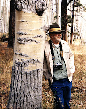
I have been wanting to take some decent photographs of quaking aspens in the snow for quite some time. I decided a few years ago that the only way this was going to happen was to go to Flagstaff when a snow storm is coming, hole up in Little America and sally forth from time to time to do some photography. Storms have come and gone over several years without me going to Flagstaff to be in one. I finally faced the facts, which are these: I hate being cold and wet and despise driving on snowy, icy roads. Therefore the chances of me deliberately going to Flag in the middle of a snowstorm are slim and none. So one day last week I rounded up an old white haired guy and went to Flag for the day. Below--Old White Haired Guy


The weather was beautiful;clear blue skies with an occasional white cloud, no wind, Phoenix temp 80+, Flagstaff temp 61. We drove from Flag to the west of Mt Humphries and north on the highway that leads to the South Rim of the Grand Canyon. We stopped at some aspen groves along the highway that had a turnout associated with them. Otherwise we couldn't stop the car along the highway because of the snow. We were at an elevation of 8000' plus, and there was plenty of snow, although it wasn't too cold. As seen below we were able to take advantage of a snowmobile track so we could walk in the snow without sinking in up to our butts.


The quakies in the snow are beautiful. Below are a couple of photos.


While walking along the snowmobile track we came to this magnificent old quakie. I don't know if this monarch of the forest is still alive, but I hope so. I plan on going back in late spring to see.


We stopped in Flag on the way home, had lunch,and took out a bank loan so we could buy enough gasoline to get home. While filling the Jeep with gas we noticed the cat below at the attached car wash cleaning the inside of his car. Apparently he exists in a portable anti-gravity bubble. I can think of no other explanation for his pants not being on the ground.


We drove on what I call the back way going and coming home. This road runs from Mesa through Payson, Pine and Strawberry and alongside Mormon Lake and Lake Mary. On the way home we saw a bunch of waterfowl in the shallow end of Lake Mary in an apparent feeding frenzy, probably after a school of fish, and a bald eagle flying close to them to see what was going on. No place to stop so no photos. I have traveled this road for at least 30 years and have never seen a bald eagle along it before. A fitting end to a great day.

Tuesday, March 1, 2011

Mesa Citrus: Going.....Going.......


When European settlers first got to the Mesa/Phoenix area they found a system of canals leading from the Salt River. The early settlers made use of these abandoned Hohokam Indian canals to attempt to get water from the Salt River to their crops. Below is a photo of an ancient Hohokam canal.

This water source was trouble because of drought and flooding. In 1902 the National Reclamation Act was passed. This act allowed for low cost loans from the Federal government for reclamation projects. The Salt River Valley Water Users' Association was formed in 1903. Members pledged some 200,000 acres of their own land as collateral and a loan was granted that resulted in the construction of Roosevelt Dam, at the junction of the Salt River and Tonto creek. The dam, the highest masonry dam ever built(280 feet), was completed in 1911. In 1996 it was encased in concrete and 77 feet added to the height, increasing its capacity by over 20%.Other dams were built later on the Salt and Verde river system and a series of canals built to carry water to the southern half of the Phoenix metropolitan area. As a result of these canals agriculture was much more successful. One of the crops planted to take advantage of the climate and this stable water source was citrus. Roosevelt Dam and a modern Salt River Project canal are shown below.


Approximately 80 years ago the citrus farmers formed an association, the Mesa Citrus Growers Association. They built a packing/shipping plant in central Mesa and shipped citrus from there under the Sunkist brand. They shipped up to one million boxes of fruit a year. In 1990 there were 45 growers who were members of the association. In June of 2010 their numbers had shrunk to 13; that spring after shipping 220,000 boxes they decided to close the plant. Below are some photos of the closed plant.


The man climbing up the fence is not homeless, but my photo buddy and son-in -law Matt Reed trying to get a better vantage point.

What happened? As I see it the biggest factor is the loss of citrus groves to housing. Most of the time a developer simply strips all the trees off and then builds houses.

Some of the upper end developments have left a row of trees around the edges made a gated community and given them uppity names like “The Groves”. A few have left the trees intact except to make roads and included irrigation water rights to the lots. We live in such an area. You can see the rows of citrus in our front yards in the photo below.


In our grove the citrus was planted in strips of type. Our lot had all navel orange trees; the house east of us has navels on the west half of the lot and Valencia or Arizona sweet oranges on the east half. A neighbor several houses east of us had all lemons. Our house was built in 1972 and some of the original trees have died. We have replaced them with navels, a grapefruit tree, a lemon tree, a lime tree and a tangerine.

There are still some commercial groves. They sell fruit locally through their own retail stores(see below) and some ship to Yuma or out of state for packing and distribution.


Below is a photo taken at a still functioning commercial grove.


Notice that the natural growth of the tree forms a skirt that goes virtually to the ground. This protects the trunk from sunburn. We suburbanites with citrus don't allow this skirt to develop so we can mow our lawns; thus the white painted trunks shown on our neighborhood trees to prevent sunburn. Two other items of interest in this picture: the tall fan and the square cut of the rows of trees. The fan stirs the air on cold nights to try and prevent frost damage. The trees are trimmed square by a frame with mechanical saws that fits over a row of trees and moves along the row trimming the trees to a uniform squareness. Makes picking and general care much easier.

One of the nice things about citrus is that you don't have to pick them all at once the minute they get ripe. Leave them on the tree—they last a long time. We start picking oranges in December and pick as needed until they are gone, usually some time in April. Real living is orange juice squeezed each day from oranges picked that morning. Our grapefruit season starts in February and runs until about August. The longer a grapefruit is on the tree the sweeter they get. Below are some of our home grown fresh picked citrus. Enjoy!