Saturday, November 20, 2010
Chaco Canyon
Chaco Canyon National Historical Park is a National Park Service site that contains the largest collection of stone masonry ruins north of Mexico. It dates from about 850 AD to 1250 AD. It was built and populated by people referred to as Anasazi by the Utes and Navajos, which means "enemy ancestors" or "ancient ones." These people are thought to have been the ancestors of modern Pueblo peoples and are also referred to as "ancient or ancestral Puebloans".
Chaco is located in the four corners area of New Mexico southeast of Farmington. It is about 6200 feet elevation. The climate is high desert, with an average of about 9 inches of rain per year. Temperatures range from well below zero in the winter to 102 or so in the summer. Water is not plentiful in this area. Scientists say that the climate has not changed appreciably since the Chacoans setled there. One of the great mysteries to me is why? Why settle here instead of a more hospitable area?
The Anasazi culture included the Mesa Verde, Betatakin, Aztec, Hovenweep, and Canyon de Chelly villages and people. Chaco Canyon with its villages, called Great Houses, numerous kivas and dwellings is thought to be the religious and trading center of the Anasazi people. They built genuine roads out from Chaco. Trade goods from Mexico-Central America have been found, including macaws, copper bells, etc. Traces of cacao have also been found.
No one knows for sure why they abandoned these settlements and moved on, but the most common explanation is a 50 year drought that started in 1130 AD. The modern Pueblo people have oral traditions about their journey away from Chaco. They also regard the ruins as sacred; the Zuni and Laguna people return on the summer solstice for dances and ceremonies.
The ruins show evidence of master planning and fairly sophisticated engineering. The tallest part of the structure appears to have been 5 stories high. There is evidence that they made astronomical observations of the solstices, equinoxes and lunar cycles. The Great House at Pueblo Bonito is laid out with the straight front wall on the east-west axis and bisected by a north-south wall. The GreatHouses are generally laid out this way and some also on either the east-west axis or the north -south axis leading to Pueblo Bonito.
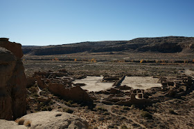
Above is a photo of Pueblo Bonito take from the mesa/cliff behind it. You can see the D shape of this 650 room structure and its two axes, north-south and east-west. You can also see the many kivas in this pueblo.
The photo above is the first part of the trail to the top of the cliff, through the talus at the bottom of the cliff. Part way up you get into a crack which takes you to the top, and is much easier than the bottom talus. The two photos below are in the crack.
Below is a photo of walls and rooms at the southeast corner of Pueblo Bonito.
The photo below shows a corner door. There are seven of these in Pueblo Bonito. Architects say this is supposed to weaken the walls. I suppose that may be true, but these have been there about 1000 years. The wood is original.
Below is a photo of an original ceiling at Pueblo Bonito.
Below is an unusual "keyhole" door at Pueblo Bonito.
Typical masonry with a beam sticking out is shown below. The mortar is mud. Timber was brought to Chaco from as far as 50 miles away, such as from the Chuska mountains or the Mt. Taylor region.
Below is the great kiva at Casa Rinconada, directly south of the wash from Pueblo Bonito. I believe this is the largest known kiva in the southwest. Four huge tree trunks held up the roof. 3-400 people could be in this kiva for a meeting or a ceremony. According to current scientific thought, the kivas were deroofed and any contents removed by the Chacoans when they were abandoned. Some were apparently burned.
At the Great House of Chetro Ketl there are the remains of colonnades along one wall, shown below. The spaces between were filled later for some reason or another. The nearest colonnades were constructed by the Toltecs in Mexico or Central America.
Chaco Canyon is one of the most interesting places I have ever been. The first time we went there as a family we camped about three feet from a ruin wall. There are many unanswered questions about this place which we are probably not going to get answers for, at least in this life.
Sunday, November 14, 2010
Strange Events
A couple of weeks ago I was coming home just after sundown. A few blocks from home I saw this strange horse coach driven by a ghost. Scared, I drove home to find a group of ghosts dancing around a cauldron in our front yard. I think the coachman must have let them off at our house.
I ran in the house and found a strange kitty cat on our table.
I ran outside and found a ghost with Harry Potter, a cowgirl, the kitty and Captain Hook.
I was uncertain what to do. I asked my wife and she suggested we try bribing them. We got out all the candy we had and sure enough, they would take some and go away.
Below are some of the strange creatures who came to our house.
We managed to bribe them all with candy, including the devil. I was sure he wanted souls but he took the candy and went on his way. The next morning the dancing ghosts and the coach were gone. Did you have this kind of trouble at your house?
Monday, October 11, 2010
Doors
For some years now doors have been one of my favorite photographic subjects. I have shot them with 4x5, 645, 35mm and various digital cameras. The photo above is from the Topkapi palace in Istanbul. It was taken with a Sony a100, Carl Zeiss 16-80 lens. Below are a few of my favorites.
Detail from old door Miami, Az. Taken with Sony a900 and Zeiss 24-70 lens.
Amsterdam door. A100 with Zeiss 16-80.
Santorini door. a100, Zeiss 16-80.
Details on door at Hubbell Trading Post, Ganado, Arizona. Digital camera, unremembered model.
Doors at Aztec Ruins, New Mexico. A100 with Zeiss 16-80.
I am thinking of doing a book of doors. I have a whole bunch more photos of doors. What do you think? Please respond to the poll. Thanks much.
Sunday, October 3, 2010
Mud, Mules, and Mountains
My father was called to active duty in January 1941 and remained on active duty until January 1 1946. He was overseas in combat for three and one half years(see blog entry of June 19, 2009). I was three and one half years old when he left and six years old when he returned. While he was gone I looked forward to every letter, photograph, etc that he sent home. One day a long wooden box arrived, which I opened, with help. I pulled out a long cavalry saber which he had acquired from a French army warehouse in North Africa. I was four years old at the time. I could barely get it off the floor with two hands and all my strength, but since it came from my dad, I was thrilled. I said “Oh boy, just what I've always wanted!”
Dad would send home postcards and pamphlets that he thought we might find interesting, and sometimes cartoons done by Bill Mauldin. Bill Mauldin was a young GI in the 45th Division who had joined the Army by way of the Arizona National Guard in 1940. Bill was a cartoonist who did some cartoons for the 45th Division newspaper and then later was picked up by Stars and Stripes, the Army newspaper. Eventually he was pulled out of line, given his own Jeep and did cartooning full time. He was a combat infantryman before being pulled out and after being pulled out spent three days out of 10 at the front. He was wounded by mortar rounds at Monte Casino in Italy. Since he covered much of the same ground as my father(Sicily, Italy, Southern France)I was very interested in his cartoons.
Bill Mauldin received the Pulitzer Prize in 1945 for his cartoons. Shortly after the war he published a book of his cartoons, along with his comments on the war. The book is called Up Front. As a kid I read and re-read that book so many times I practically wore it out. Mauldin became an editorial cartoonist for the St. Louis Post Dispatch and the Chicago Sun Times and won a second Pulitzer in 1958 or 1959.
Below is a typical Bill Mauldin cartoon, with Willie and Joe, his usual GIs, dog faces, grunts,also known as combat infantry enlisted men, in a pile of rubble.
A few months ago we sold my dad's house and finished cleaning it out. As we were going through his books, there were two copies of Up Front, and in one of them was a 6 x 9 inch paper pamphlet entitled Mud, Mules, and Mountains by Bill Mauldin, with “Mike” written on the outside cover in my mother's hand writing. It's about 40 pages long, with cartoons from the Italian campaign, and an introduction by Ernie Pyle. Ernie Pyle was probably the most famous war correspondent of WWII. Like Bill Mauldin he went to the front with the infantry and told their story. Ernie went to the Pacific theatre before the war ended and was killed there.
I was quite pleased to find this and I do not remember seeing it before. I suspect that I saw it when we first got it and then my mother put it away for safe keeping. I had looked through it once when we found it, and was looking through it again at home when I noticed something bleeding through the fly leaf. The fly leaf was clinging to the front cover. I pulled it away and saw the inscription shown below.
I think that dad got this at an Italian naval base. His outfit was in line near Florence and was pulled out and sent back to refit for the invasion of Southern France. The date on the inscription is August 5. D-day for Southern France was August 15, in which his outfit participated.
Thanks, Dad, from your little boy, Mike. And thanks, Mom, from your big boy.
Sunday, September 5, 2010
Winter Quarters
The Mormons were forced out of Nauvoo, Illinois beginning in February 1846. At first they crossed the Mississippi River to Montrose, Iowa on ice. The Mississippi was frozen solid enough to support teams and wagons. As the ice melted they crossed with the aid of ferries(see previous post of August 27 2010). You can follow their route across Iowa by car. Road maps show the highways closest to their route and the highways have Mormon trail signs on the side of the road. The route was very slow going, with deep mud, snow, cold, hills and streams to cross. It took them about 4 and 1/2 months to go from Nauvoo to what they called Winter Quarters, on the Iowa side of the Missouri River, at what is now Council Bluffs. It only took three months to go from Winter Quarters to the Salt Lake Valley, at least 3 times the distance.
Below is a photo of some original Mormon trail ruts still visible in the Iowa sod.
At Winter Quarters they gathered together, built shelters and outfitted themselves for the long trek to the Salt Lake valley. Some 600 people are buried in unmarked graves in what was the Winter Quarters cemetery.
This whole site is now known as the Mormon Trail Center and includes a visitors' center, a Temple, several memorials and the old Winter Quarters Cemetery.
There are no markers in what was the cemetery but a memorial is there, designed by the sculptor Avard Fairbanks.
The plaque at the bottom of the photo contains the names of the 600 pioneers who are buried here. Included on the plaque are a great aunt of mine and at least one of her babies.
There were many small settlements around Winter Quarters where the Mormons stayed while they outfitted themselves to go west. My great-great grandmother and four of her children stayed at a place called Pigeon Creek or Pigeon Hollow. She was 52 years old, had buried her husband in New York and came to Nauvoo only to be thrown out of there. Her brother, Warren Foote, and his family were also there. She told Warren she was too tired to go on and died a few days later, along with a son who was about 20, I believe. My great grandfather, Darius Salem Clement, was 12 years old and the oldest of the three remaining children. Betsy and Albert are buried in unmarked graves in what is now the Branson Cemetery on a hill overlooking the Missouri River. Darius and the two other younger children walked to Salt Lake in 1848.
There were at least 6000 Mormon pioneers who died on the trail to the Salt Lake valley between 1846 and 1869, which is when the transcontinental railroad was completed. Below is the Avard Fairbanks sculpture at the Winter Quarters Cemetery memorial. This shows a man and wife who have just finished digging a grave and laying their child in it. It is one of the most moving pieces of art I have ever seen.
Friday, August 27, 2010
Nauvoo, Part 2
In 1839 when the Mormons arrived at the place in Illinois they eventually named Nauvoo, it was a small town called Commerce. They bought the site in 1840 and renamed it Nauvoo. They Mormons cleared land between the Mississippi river and the hill or bluff upon which they built a Temple. The land east of the bluff was very flat. In 1844 there were 15,000 people in Nauvoo, making it the second largest city in Illinois. It was not a typical frontier settlement. There were many craftsmen, tradesmen, etc. in Nauvoo. Many converts to Mormonism from England, Canada and the eastern United States settled there and plied their trade. Consequently there was not much need for outside goods which was one of the sore points with others in the area. The other Illinois residents were also afraid of them voting as a block.
The photograph below shows a section of prairie in Nauvoo that has been restored to its original state. The woman in the photo is about five feet two in height.
Below is a photograph of the Mansion House. It was used at various times as a home for Joseph and Emma Smith and as a hotel.
The handsome red brick home below is Brigham Young's home. The red brick is typical of locally made brick and is sometimes known as "Nauvoo red brick."
The small building below is a boot and shoe shop owned by a man from Germany named Riser. It also served as the family home.
This is inside the shop and shows a number of lasts on the wall along with other items related to the shoemaker's trade.
This photo shows a tool used to cut heels from leather. The cut pieces were then stacked together until the correct heel height was obtained. You can also see a bin of wooden pegs used to attach the sole, as well as a bin of small brads.
Below is a view of the Smith family cemetery, literally on the bank of the Mississippi. Joseph's father and mother, his wife Emma and his brother Hyrum are all buried here.
Blacksmith at work.
This is a stock used to support an ox while it is being shod. Unlike horses, oxen cannot support themselves on three legs, so the stock is necessary to keep them upright while the farrier shoes them.
I may be wrong but I believe that below is a photo of the only ceramic defecatorium I have ever seen, although they are fabled in song and story.
Below is John Browning's house and shop. John Browning was a gunsmith as well as blacksmith.At this time(1844) he was making regular guns as well as slide guns, which were a repeating rifle in which a clip fed in rounds from the side as opposed to vertically. The clip held up to 25 rounds. John and his family traveled to Utah with the rest of the saints and established the Browning gun works in the Ogden--Morgan area. His son, John Moses Browning, was a firearms genius. He developed the Browning light machine gun, still used by armies around the world, the US Army .45 pistol(sold the rights to Colt), most if not all the machine guns used on US aircraft in WWII, the Browning Automatic Rifle(BAR)used extensively by US infantry in WWII and Korea, and many other innovations. Browning Arms are still associated with quality and innovation.
This rocking horse was the prized possession of John Taylor's small boy at the time they were forced out of Nauvoo. With a limited ability to take necessities, the rocking horse was left behind when they crossed the Mississippi. The boy was inconsolable, and his father returned to Nauvoo and brought the rocking horse to the boy. It made it all the way to Salt Lake City, and was eventually returned to Nauvoo by the Taylor family.
This is the landing at the foot of Parley Street. It was here that boats landed and from here that the Mormons crossed the Mississippi to Montrose, Iowa when they were forced to leave Nauvoo. They began leaving in February, 1846, driving teams and wagons across the river on the ice.
When the ice melted they crossed the river on ferries, such as the one shown below.
Nauvoo from Montrose, Iowa with the Temple prominent on the bluff. This is what the Mormons last view of Nauvoo would have been.