Below is a satellite view of Venice.

The main part of Venice is the large group of islands in the central part of the photo. The islands at the bottom of the picture are considered to be out in the lagoon and are accessible only by boats. Ships approach from the bottom right corner, passing between the bottom islands and the main part of Venice to the port located at the far left. The railroad station and the causeway to the mainland are just above the port facilities. The Grand Canal is the larger "S" shaped canal running from the vicinity of the train station to the lagoon just below dead center in the photo. St. Mark's and the Doge's Palace are just to the right of the entrance to the Grand Canal on the lagoon. Below is an aerial view of Venice.

Venice was a major maritime power in the Middle Ages and Renaissance. Between the 13th and 17th centuries the Adriatic was virtually a Venetian lake. Venice for many years during this time was the wealthiest city in Europe, based largely on commerce. Venice was heavily influenced by the Byzantine, as can be seen today in both it's art and architecture.
The photos were all taken by me from our ship as we sailed into Venice. They were all shot from one of the top decks and are of the lagoon shoreline of Venice.
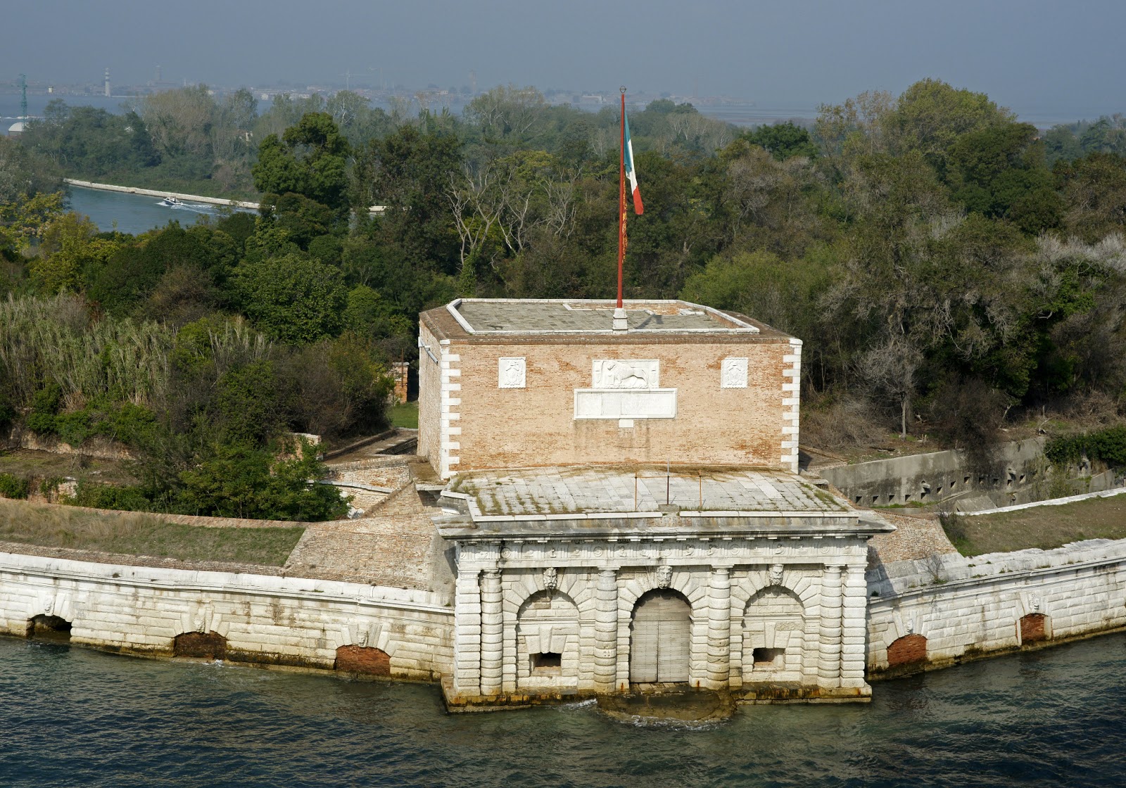
The photo below shows a fortification just about at the point that ships turn to go up the lagoon. Notice the Lion of St. Mark on the fort. This lion is the sign of Venice and is found all over the Adriatic.


The photo below is where another small canal empties into the lagoon. The bridge is typical, used by foot traffic, and tall enough so boats can pass beneath. The two small structures with yellow stripes in the lower right hand corner are vaporetto stops. The vaporettos are municipal water buses.


Above is another canal and bridge.

The hotel above looks inviting, but I can't vouch for it.

The church in the above photo is the Santa Maria della Pieta. It is known as Vivaldi's church because he wrote music and performed it in this church. The interior is oval shaped and is supposed to have fine acoustics. It is up the lagoon a little ways before you reach the Doge's Palace and St. Mark's.

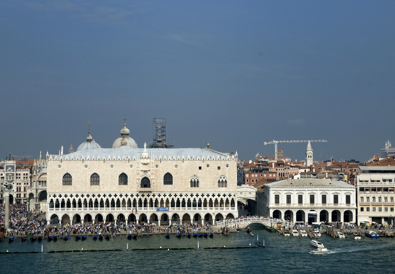
This photo shows the Doge's Palace, the large building tin the center fronting on the lagoon with all the repeating arches on the ground floor. The Campanile of St. Mark's is the tower shown; the entrance to St. Mark's square is to the left of the palace.
Above is a direct on view of the Doge's palace. St. Mark's Cathedral is behind the palace. On the right side of the palace coming from an upper story is a bridge connecting to another building--the prison. The bridge is the Bridge of Sighs, named by the poet Lord Byron. Byron's idea was that the prisoner's last view of Venice as he crossed the bridge would cause him to sigh mournfully.

The view above shows the Campanile, St. Mark's square, St. Marks seen from the side and the Doge's palace. Below St. Mark's is seen a little better.

The photo below is a little past the Doge's palace.


The boat shown above is a private sight-seeing boat.
The two photos below are of the Church of the Gesuati. Note the vaporetto stop just to the left of the church. This church was named after the Jesuits, but not built by them.


Above is another small canal and bridge. We are approaching the port area.

Above is the last vaporetto stop and small canal before the port. Below is another view showing the beginning of the port on the left with the vehicles and the chain link fence.

This way of coming into Venice provided a great introduction to the city. Stay tuned for more!
A note on the facts quoted in the beginning: from the Wikipedia entry on Venice. The satellite and aerial views are from Wikimedia commons.
The rest of the photos on this entry were all taken by me from the eighth deck of the Nieuw Amsterdam, between about 1200 and 1300 hours. A Sony a900 camera with a Zeiss 24-70 lens were used for all of them.
Nice photos. I felt like I was there--oh I was. Your pictures look better than real life. Cheryl
ReplyDeleteThank you. You are too kind, as always.
DeleteNice views of the "boot."
ReplyDelete